

Avalanche Advisory
| Advisory: Uintas Area Mountains | Issued by Craig Gordon for March 13, 2013 - 6:25am |
|---|


Above treeline
Near treeline
Below treeline
|
bottom line In the wind zone at and above treeline, a MODERATE avalanche danger exists and human triggered avalanches are possible on steep, wind drifted shady slopes. In addition, a MODERATE avalanche danger exists for triggering a deeper avalanche that breaks into weak snow in the mid portion of the snowpack. The most likely suspects are steep, rocky terrain where strong feeling snow overlies weak sugary snow. LOW avalanche danger exists on low angle, wind sheltered terrain.
|

 |
current conditions High pressure is building and skies are clear this morning. West and northwest winds are blowing 15-25 mph along the high ridges and temperatures are in the low to mid 20's. On a go anywhere base, the surface snow remains cold and creamy on upper elevation, wind sheltered, shady slopes. Recent observations can be found here. Our entire Uinta weather station network is up and running. A link to real-time wind, snow, and temperature data can be found here. This monumental achievement couldn't have happened without the joint efforts from the National Weather Service, The Heber-Kamas and Evanston Ranger Districts, Park City Powder Cats, and all the great work by Ted, Trent, Cody, and Al. Thanks to everyone... this is awesome! Wondering why last winter was so crazy? Click here to watch the 2011-12 Utah Winter Review... an excellent recap of last years conditions.
|
 |
recent activity
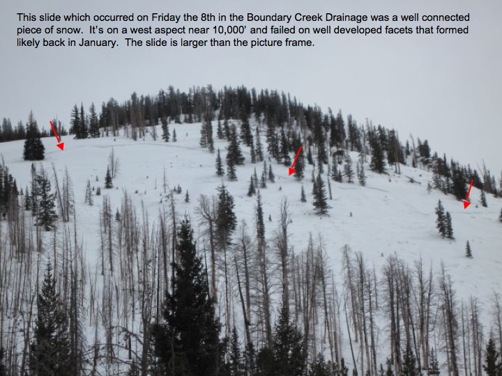
Yesterday, Ted took a look at this slide near the Boundary Creek Yurt which was remotely triggered Friday as a group of skiers were ascending the slope. Averaging 2' deep, 500' wide, and running about 600' vertically, this slide broke into a weak layer of faceted snow formed during the cold dry spell in early January. Click here for the rest of Ted's great report of this eye opening slide. Click here for recent observations from the region. |
Avalanche Problem 1over the next 24 hours
| type | aspect/elevation | characteristics |
|---|
 |


Above treeline
Near treeline
Below treeline
|
|
|
description
A few wind drifts, sensitive to the weight of a rider will be found today on steep, upper elevation, wind drifted slopes. While mostly manageable in size and depth, there may be a rogue slab or two large enough to knock you off your skis, board, or sled, especially in steep, complex, committing terrain. Rather than blindly center punching a big bowl or technical chute, gather information as you travel throughout the day. Tweak small test slopes and road cuts and find out a little bit more about the characteristics of the avalanche dragon you're dealing with, giving you the kind of baseline info you need to help make solid terrain choices today.
|

Avalanche Problem 2over the next 24 hours
| type | aspect/elevation | characteristics |
|---|
 |
Above treeline
Near treeline
Below treeline
|
|
|
description
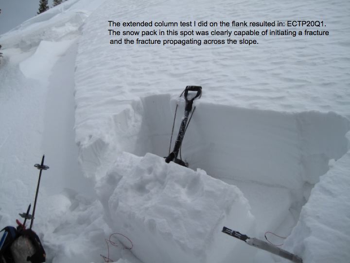
Persistent slabs... we've been talking about this problem child since the turn of the New Year. We might have forgotten about this layer, but the snowpack has an amazing memory. The problem with a persistent weak layer buried in the snowpack, is that it comes back to life each time it goes through a rapid change whether it's reloaded with snow, strong winds, or rapidly warming temperatures. Bottom line- persistent slabs are tricky, dangerous, and can't be trusted. All we need to do is find a weakness in the snowpack, collapse it, and we're staring down the barrel of a dangerous slide. While not widespread, there are areas where strong feeling snow overlies weak, sugary snow. Best way to combat a situation like this is with terrain choice and by considering the consequences of triggering a slide.
Ted's pit profile from Boundary Creek reveals it takes some force to initiate a slide, but the quality of shear suggests the slab is like a tightly wound rubber band is waiting to snap when we find a weak spot in the structure.
|
Avalanche Problem 3over the next 24 hours
| type | aspect/elevation | characteristics |
|---|
 |
Above treeline
Near treeline
Below treeline
|
|
|
description
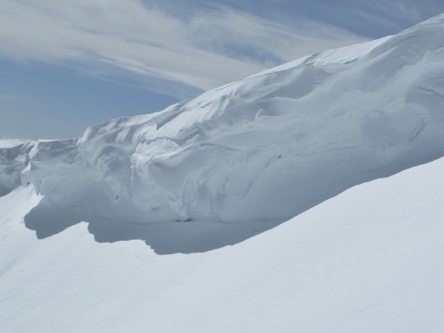
Cornices continue to grow in size and unpredictability. |
 |
weather High pressure building over the region leads to sunny skies, west-northwest winds blowing in the 20's, and temperatures warming into the mid 40's. Skies remain clear overnight and temperatures dip into the mid 20's. Not much change in the weather department til later in the weekend when a series of weak storms tries to break through the ridge. While most of the energy deflects to our north, we might see a stronger system sliding through the region on Sunday.
|
| general annoucements Remember your information can save lives. If you see anything we should know about, please participate in the creation of our own community avalanche advisory by submitting snow and avalanche conditions. You can call me directly at 801-231-2170, email [email protected], or email by clicking HERE This is a great time of year to schedule a free avalanche awareness presentation for your group or club. You can contact me at 801-231-2170 or email [email protected] Donate to your favorite non-profit –The Friends of the Utah Avalanche Center. The UAC depends on contributions from users like you to support our work. The information in this advisory is from the US Forest Service which is solely responsible for its content. This advisory describes general avalanche conditions and local variations always occur. The information in this advisory expires 24 hours after the date and time posted, but will be updated by 7:00 AM Saturday March 16th. |