

Avalanche Advisory
| Advisory: Salt Lake Area Mountains | Issued by Drew Hardesty for March 13, 2013 - 6:32am |
|---|


Above 9,500 ft.
8,000-9,500 ft.
Below 8,000 ft.
|
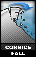
bottom line We have a mostly LOW danger in the mountains this morning. The danger will - of course - rise to MODERATE on the steep easterly to southerly to westerly facing slopes with direct sun and daytime highs approaching the 40s and 50s today. Cornice fall and roof-a-lanches are the other concerns today.
|

 |
current conditions Clearing skies and overnight lows in the upper 20s and low 30s will provide a decent refreeze for all but a few outlier spots noted in the Provo and Ogden area mountains. The westerlies are light except for the 10 and 11,000' ridgelines where they are blowing 15-20mph with occasional gusts to 35. Lingering high humidity may foster some surface hoar development in many locations - which may be the most "new snow" we see perhaps until Sunday. Riding conditions are fair...though I suspect the corn harvest will be on in the next day or two. |
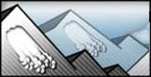 |
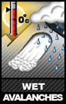
recent activity Little in the way of activity yesterday except for some shallow loose wet sluffs and some roofs shedding their winter coat. Below is a pic taken by Peter Daines of a close call in Wolverine from Sunday.
|
Avalanche Problem 1over the next 24 hours
| type | aspect/elevation | characteristics |
|---|
 |


Above 9,500 ft.
8,000-9,500 ft.
Below 8,000 ft.
|
|
|
description
Low danger doesn't mean no danger. Here are a couple things to be mindful of today -
TERRAIN SELECTION IS CRITICAL - As the overall danger decreases, many people look to bigger or longer or more radical objectives that can often involve a rope, axe, and plenty of side-slipping (and still call it "skiing"). As you ramp up your exposure - remember - Nothing can go wrong. Nothing. Even an isolated small 5" deep wind pocket that pulls you off when above unforgiving terrain can mean curtains. It doesn't matter what tool you have - snowboard, snowmobile, snowshoes, crampons. I've lost more than a couple friends in the mountains from even the smallest avalanches. Pay attention. Make good choices. |

Avalanche Problem 2over the next 24 hours
| type | aspect/elevation | characteristics |
|---|
 |
Above 9,500 ft.
8,000-9,500 ft.
Below 8,000 ft.
|
|
|
description
|

Avalanche Problem 3over the next 12 hours
| type | aspect/elevation | characteristics |
|---|
 |
Above 9,500 ft.
8,000-9,500 ft.
Below 8,000 ft.
|
|
|
description
Avoid the steep sun-drenched slopes during the heat of the day. Change your slope angle or aspect or get an earlier start tomorrow. |
 |
weather Springtime in the mountains, climbing and biking, yard work and taxes in the valley. Clear skies and light to moderate westerly winds. 8 and 10,000' temps will soar into the upper 40s/low 50s and mid to upper 30s at 10,000' today. Clear skies persist through Friday with 10,000' temps approaching the low 40s perhaps by later Thursday. A couple of weak systems are on tap for the weekend. Models hint at a large scale pattern change (back to winter) by the first day of spring. |
| general annoucements Go to http://www.backcountry.com/utah-avalanche-center to get tickets from our partners at Beaver Mountain, Canyons, Sundance, and Wolf Mountain. All proceeds benefit the Utah Avalanche Center. If you trigger an avalanche in the backcountry - especially if you are adjacent to a ski area – please call the following teams to alert them to the slide and whether anyone is missing or not. Rescue teams can be exposed to significant hazard when responding to avalanches, and do not want to do so when unneeded. Thanks. Salt Lake and Park City – Alta Central (801-742-2033), Canyons Resort Dispatch (435-615-3322) Ogden – Snowbasin Patrol Dispatch (801-620-1017) Powder Mountain Ski Patrol Dispatch (801-745-3772 ex 123) Provo – Sundance Patrol Dispatch (801-223-4150) Dawn Patrol Forecast Hotline, updated by 05:30: 888-999-4019 option 8. Twitter Updates for your mobile phone - DETAILS Daily observations are frequently posted by 10 pm each evening. Subscribe to the daily avalanche advisory e-mail click HERE. UDOT canyon closures UDOT at (801) 975-4838Wasatch Powderbird Guides does daily updates about where they'll be operating on this blog http://powderbird.blogspot.com/ .Remember your information can save lives. If you see anything we should know about, please participate in the creation of our own community avalanche advisory by submitting snow and avalanche conditions. You can also call us at 801-524-5304 or 800-662-4140, email by clicking HERE, or include #utavy in your tweet. Donate to your favorite non-profit –The Friends of the Utah Avalanche Center. The UAC depends on contributions from users like you to support our work. For a print version of this advisory click HERE. This advisory is produced by the U.S. Forest Service, which is solely responsible for its content. It describes only general avalanche conditions and local variations always exist. Specific terrain and route finding decisions should always be based on skills learned in a field-based avalanche class. |