

Avalanche Advisory
| Advisory: Provo Area Mountains | Issued by Drew Hardesty for November 14, 2012 - 6:54am |
|---|


 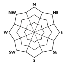
Above 9,500 ft.
8,000-9,500 ft.
Below 8,000 ft.
|
bottom line Localized areas of MODERATE danger still pocket the northwest through north through northeast facing terrain above about 9000'. Human triggered slides up to 2' deep are possible. Outside of this terrain, the danger is mostly LOW, except for hitting obstacles in our still young snowpack. Remember that consequences for getting caught and carried early season are more severe as one gets raked through the thinly buried rocks and deadfall. Roof-alanches off the steep metal roofs remain likely today.
|
 |
special announcement
|
 |
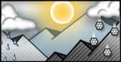
current conditions Skies are mostly cloudy to overcast with winds out of the west blowing 10-15mph. Temps have rebounded from lows in the single digits on Sunday/early Monday and sit in the upper 20s to low 30s. Melt-freeze crusts now exist on all of the sunny aspects but soft settled powder can be found on the mid and upper elevation shady terrain. Riding conditions remain quite good. |
 |
recent activity There were much fewer people out and about yesterday and we heard about no new avalanches in the backcountry. Isolated collapsing or "whoomphing" was noted, though far from the rattling thunderclaps from only a few days ago. Avalanche teams in upper Little Cottonwood had mixed results, with some explosive work pulling out a few 2-3' deep pockets in high north facing terrain. Your observations from the backcountry can help save lives. Click - This is also Why Your Observations Matter -
|
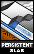
Avalanche Problem 1over the next 24 hours
| type | aspect/elevation | characteristics |
|---|
 |
Above 9,500 ft.
8,000-9,500 ft.
Below 8,000 ft.
|
|
|
description
It was a bit too quiet for my liking yesterday. Other than some explosive released old snow avalanches, nothing went reported. Little to no collapsing of the old October snow. My snow tests on high east facing demonstrated only moderate results at best. It's true that the old October 23/24 snow has adjusted better to the blockbuster storm over the weekend...and it's true that the storm snow has settled into a more dense slab. It's also true that many may assume that our problems are over and then hit the steep lines with abandon...and get away with it. I suspect - now as we pivot toward a lower probability/high consequence scenario, folks might tend to push their luck.
|

 |
weather We'll have mostly cloudy skies with more moisture riding west to east along the northern part of the state. Winds will be westerly at 15-20mph. With temps just below freezing at 8000' and 10,000'. Skies clear out over the next couple of days ahead of a weak looking system for later in the weekend. |
| general annoucements If you trigger an avalanche in the backcountry - especially if you are adjacent to a ski area – please call the following teams to alert them to the slide and whether anyone is missing or not. Rescue teams can be exposed to significant hazard when responding to avalanches, and do not want to do so when unneeded. Thanks. Salt Lake and Park City – Alta Central (801-742-2033) Ogden – Snowbasin Patrol Dispatch (801-620-1017) Provo – Sundance Patrol Dispatch (801-223-4150) Dawn Patrol Forecast Hotline, updated by 05:30: 888-999-4019 option 8. Twitter Updates for your mobile phone Daily observations are frequently posted by 10 pm each evening. Subscribe to the daily avalanche advisory e-mail click HERE. UDOT canyon closures UDOT at (801) 975-4838 Wasatch Powderbird Guides does daily updates about where they'll be operating on this blog http://powderbird.blogspot.com/ . Remember your information can save lives. If you see anything we should know about, please participate in the creation of our own community avalanche advisory by submitting snow and avalanche conditions. You can also call us at 801-524-5304 or 800-662-4140, or email by clicking HERE Donate to your favorite non-profit –The Friends of the Utah Avalanche Center. The UAC depends on contributions from users like you to support our work. We will update this forecast tomorrow. Thanks for calling. |