

Avalanche Advisory
| Advisory: Ogden Area Mountains | Issued by Brett Kobernik for February 14, 2013 - 6:44am |
|---|


Above 8,500 ft.
7,000-8,500 ft.
Below 7,000 ft.
|
bottom line There is a MODERATE overall avalanche danger today. Heightened danger can be found along ridges where the wind has drifted snow into fresh drifts. Human triggered avalanches are possible or maybe even likely if you provoke these drifts. Especially watch for these if you are in areas that have a thinner and weaker preexisting snowpack. Shallow rocky spots scattered throughout deeper snowpack areas are suspect as well.
|

 |
special announcement Drew Hardesty will be giving a "Fireside Chat" about current avalanche conditions at Black Diamond tonight, it starts at 7:30pm. Bring picnic supplies. |
 |
current conditions The winds have increased overnight into the moderate and strong category. They are generally west or northwest and may have peaked in speed over the last couple of hours. Temperatures are in the teens to low 20s. We've had some snow showers this morning containing some graupel with a couple of inches of accumulation. |
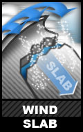
Avalanche Problem 1over the next 24 hours
| type | aspect/elevation | characteristics |
|---|
 |
Above 8,500 ft.
7,000-8,500 ft.
Below 7,000 ft.
|
|
|
description
You will most likely find numerous fresh wind slabs that are likely to release if provoked. These are always the most sensitive during and just after they've formed. This is a manageable problem for those with good avalanche experience in that you can recognize areas that have fresh drifts and avoid them. However, a greater concern would be where it's perhaps not quite so obvious that the wind has drifted snow into areas that have buried weak faceted snow which could then collapse. The best policy is to avoid the fresh wind drifts. This issue is most pronounced on the lee sides of ridges mostly on northeast through southerly facing slopes. Watch for crossloaded terrain features on the windward slopes as well. |

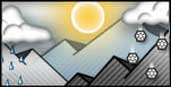 |
weather The little disturbance that bumped the winds and is giving us a little snow will move through by mid day today. We shouldn't see much more snowfall. Northwest winds will start to slow and ridgetop temperatures will get into the 20s. Clouds should break a bit as the day progresses. We'll have another small disturbance tonight into Friday morning then a warming trend into Saturday. More storms are on deck. |
| general annoucements Go to http://www.backcountry.com/utah-avalanche-center to get tickets from our partners at Park City, Beaver Mountain, Canyons, Sundance, and Wolf Mountain. All proceeds benefit the Utah Avalanche Center. If you trigger an avalanche in the backcountry - especially if you are adjacent to a ski area – please call the following teams to alert them to the slide and whether anyone is missing or not. Rescue teams can be exposed to significant hazard when responding to avalanches, and do not want to do so when unneeded. Thanks. Salt Lake and Park City – Alta Central (801-742-2033), Canyons Resort Dispatch (435-615-3322) Ogden – Snowbasin Patrol Dispatch (801-620-1017) Powder Mountain Ski Patrol Dispatch (801-745-3772 ex 123) Provo – Sundance Patrol Dispatch (801-223-4150) Dawn Patrol Forecast Hotline, updated by 05:30: 888-999-4019 option 8. Twitter Updates for your mobile phone - DETAILS Daily observations are frequently posted by 10 pm each evening. Subscribe to the daily avalanche advisory e-mail click HERE. UDOT canyon closures UDOT at (801) 975-4838 Wasatch Powderbird Guides does daily updates about where they'll be operating on this blog http://powderbird.blogspot.com/ . Remember your information can save lives. If you see anything we should know about, please participate in the creation of our own community avalanche advisory by submitting snow and avalanche conditions. You can also call us at 801-524-5304 or 800-662-4140, or email by clicking HERE Donate to your favorite non-profit –The Friends of the Utah Avalanche Center. The UAC depends on contributions from users like you to support our work. For a print version of this advisory click HERE. This advisory is produced by the U.S. Forest Service, which is solely responsible for its content. It describes only general avalanche conditions and local variations always exist. Specific terrain and route finding decisions should always be based on skills learned in a field-based avalanche class. |