

Avalanche Advisory
| Advisory: Ogden Area Mountains | Issued by Evelyn Lees for November 21, 2012 - 7:09am |
|---|


Above 8,500 ft.
7,000-8,500 ft.
Below 7,000 ft.
|
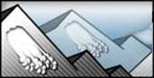
bottom line The avalanche danger is MODERATE on steep, wind drifted slopes at both the upper elevations. Drifts will be found both along the high ridge lines and down into open bowls, along sub ridges and gully walls, most widespread on northerly facing slopes. An very isolated danger also remains on the steepest, northerly facing slopes above for a slide breaking near the ground.
|

 |
special announcement UDOT Big Cottonwood will have intermittent local road closures today from 9-11am as they sight in their artillery in Stairs Gulch near Storm Mountain. More information on the UDOT avalanche program can be found below in our General Announcements. |
 |
current conditions It is a warm and blustery morning – the temperatures at most Ogden weather stations remained well above freezing, in the 40's overnight and this morning. The southerly winds are battering the most exposed peaks in the range – with averages to 40 mph and gusts in the 50s and 60s. Even at the mid elevations in the Ogden area mountains, 25 to 35 mph averages are common, with gusts to 40. Al this spells the demise of dry, cold powder. Stiff wind drifts, frozen crusts and damp snow are wide spread. |
 |
recent activity No new avalanche activity reported from the backcountry yesterday. |
Avalanche Problem 1over the next 24 hours
| type | aspect/elevation | characteristics |
|---|
 |
Above 8,500 ft.
7,000-8,500 ft.
Below 7,000 ft.
|
|
|
description
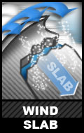
The strong, southerly winds are moving snow, both along the ridge lines and reaching well down into the mid elevation terrain. Dense, stubborn wind drifts can crack out beneath a person or sled, and are large enough to catch and carry a person. Almost any early season ride in an avalanche includes a rough journey over rocks. Avoid the wind drifted slopes by looking for telltale patterns on the snow surface, such as ripples and pillows, and jump on small test slopes to see how sensitive and deep the drifts are. |

Avalanche Problem 2over the next 24 hours
| type | aspect/elevation | characteristics |
|---|
 |


Above 8,500 ft.
7,000-8,500 ft.
Below 7,000 ft.
|
|
|
description
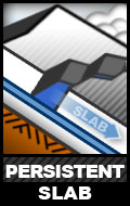
There may be a very, very few pockets of dry, loose facets near the ground in isolated places in the Ogden area mountains, that could release with the weight of the new wind drifted snow. But I am hoping the generally warm weather and snowpack will destroy the last of these soon.. |

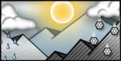 |
weather It is a bit hard to get excited about the weather today – partly cloudy skies, warm and windy, with high temperatures in the 40s and 50s this morning. Increasing clouds and gradually cooling temperatures this afternoon as a weak system moves by to the north, producing a trace of snow tonight. Winds will remain brisk overnight, but switch to a more westerly direction. Cooler temperatures on Thanksgiving, with highs only in the 30’s, followed by more warm and dry weather through Saturday. But hope for a close to the endless summer is on the horizon – a colder storm is forecast to arrive around Sunday. |
| general annoucements If you trigger an avalanche in the backcountry - especially if you are adjacent to a ski area – please call the following teams to alert them to the slide and whether anyone is missing or not. Rescue teams can be exposed to significant hazard when responding to avalanches, and do not want to do so when unneeded. Thanks. Salt Lake and Park City – Alta Central (801-742-2033) Ogden – Snowbasin Patrol Dispatch (801-620-1017) Provo – Sundance Patrol Dispatch (801-223-4150) Dawn Patrol Forecast Hotline, updated by 05:30: 888-999-4019 option 8. Twitter Updates for your mobile phone Daily observations are frequently posted by 10 pm each evening. Subscribe to the daily avalanche advisory e-mail click HERE. UDOT canyon closures UDOT at (801) 975-4838 Wasatch Powderbird Guides does daily updates about where they'll be operating on this blog http://powderbird.blogspot.com/ . Remember your information can save lives. If you see anything we should know about, please participate in the creation of our own community avalanche advisory by submitting snow and avalanche conditions. You can also call us at 801-524-5304 or 800-662-4140, or email by clicking HERE Donate to your favorite non-profit –The Friends of the Utah Avalanche Center. The UAC depends on contributions from users like you to support our work. Evelyn will update this forecast tomorrow. Thanks for calling. If you trigger an avalanche in the backcountry - especially if you are adjacent to a ski area – please call the following teams to alert them to the slide and whether anyone is missing or not. Rescue teams can be exposed to significant hazard when responding to avalanches, and do not want to do so when unneeded. Thanks. Salt Lake and Park City – Alta Central (801-742-2033) Ogden – Snowbasin Patrol Dispatch (801-620-1017) Provo – Sundance Patrol Dispatch (801-223-4150) Dawn Patrol Forecast Hotline, updated by 05:30: 888-999-4019 option 8. Twitter Updates for your mobile phone Daily observations are frequently posted by 10 pm each evening. Subscribe to the daily avalanche advisory e-mail click HERE. UDOT canyon closures UDOT at (801) 975-4838 Wasatch Powderbird Guides does daily updates about where they'll be operating on this blog http://powderbird.blogspot.com/ . Remember your information can save lives. If you see anything we should know about, please participate in the creation of our own community avalanche advisory by submitting snow and avalanche conditions. You can also call us at 801-524-5304 or 800-662-4140, or email by clicking HERE Donate to your favorite non-profit –The Friends of the Utah Avalanche Center. The UAC depends on contributions from users like you to support our work. I will update this forecast tomorrow. Thanks for calling. |