25th Annual Black Diamond Fall Fundraising Party
Thursday, September 13; 6:00-10:00 PM; Black Diamond Parking Lot

25th Annual Black Diamond Fall Fundraising Party
Thursday, September 13; 6:00-10:00 PM; Black Diamond Parking Lot
| Advisory: Moab Area Mountains | Issued by Eric Trenbeath for Wednesday - December 21, 2016 - 6:58am |
|---|


|
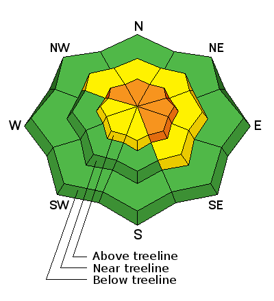
bottom line Overall, the avalanche danger is MODERATE but areas of CONSIDERABLE danger still exist on steep, upper elevation terrain that has a NW-NE-SE aspect where it is still possible to trigger a dangerous persistent slab avalanche. Heightened avalanche awareness, careful terrain selection and snowpack analysis is required in these areas. There is also a MODERATE danger for wind slab avalanches in upper elevation, wind exposed terrain. 
|
 |
current conditions The December 15-16 storm event brought about 18" of much needed snow to the mountains. Weather has been calm this week with mostly sunny skies, cool mountain temperatures, and mostly light winds. A change in the pattern is coming on Thursday with what looks like a decent storm by Christmas weekend. Base depth in Gold Basin is 39" and we have received 92" of total snowfall for the season. Storm totals and temperature in Gold Basin.(10,000') Wind, temperature and humidity on Pre Laurel Peak.(11,700') Snow totals, temperature and snow/water equivalent at the Geyser Pass Trailhead.(9600') |
 |
recent activity
The storm cycle of December 15-16, produced some large avalanches including this one in Horse Creek Chute on a NE aspect at about 11,400'. Overall I was surprised that there wasn't more activity given the prevalence of the weak, faceted layer that this and, the other slides apparently ran on. For a list of the other slides I observed go here. |
 |
weather Wednesday Partly sunny, with a high near 29. West southwest wind around 5 mph. Wednesday Night A 20 percent chance of snow after 11pm. Partly cloudy, with a low around 14. South southwest wind 5 to 10 mph. Thursday A 30 percent chance of snow. Mostly sunny, with a high near 29. South southwest wind 5 to 10 mph. Thursday Night A 30 percent chance of snow, mainly before 11pm. Partly cloudy, with a low around 17. South southwest wind 5 to 10 mph. Friday A 20 percent chance of snow. Mostly sunny, with a high near 29. |