

Avalanche Advisory
| Advisory: Moab Area Mountains | Issued by Max Forgensi for January 15, 2013 - 6:01pm |
|---|


 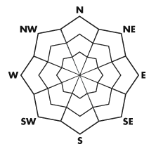
Above treeline
Near treeline
Below treeline
|
bottom line The Bottom Line for Wednesday will be an Avalanche Danger of Moderate on slopes with freshly deposited wind slabs and shady aspects that hold persistent slabs at or near tree-line locations.
|
 |
special announcement The Utah Avalanche Center - Moab will teach a basic avalanche awareness course on Friday, January 18th at 6:30 pm at the Grand County Public Library. The following day, Saturday, January 19th, there will be an Avalanche Rescue Clinic at the Geyser Pass Winter TH at 10:00 am. Both of these events are free and open to anyone who would like to attend. The 3-day AIARE Level I course on February 1st-3rd is filled. If you want to get on the waitlist, call 435-636-3355. The Utah Avalanche Center - Moab is on Facebook! Become a friend today. |
 |
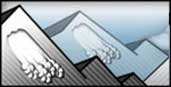
current conditions Southeast Utah is locked into deep winter. High pressure will rule over the Red Rock Desert for at least the next week, leaving inverted valleys and the mountains to slowly warm. This is the case for most of the Western United States. I would count your lucky chickens that you live where groomed corduroy, a decent snow pack and incredibly plowed trailheads and roads are something to enjoy while we wait for the desert (and our water lines) to thaw out. The Great North Wind kicked up Tuesday, scouring exposed ridgelines and depositing hard wind slabs on leeward sides of slopes and ridges. Don't be discouraged...there are plenty of sheltered below tree-line locations that hold decent supportable snow conditions on every aspect. These types of conditions should encourage people to explore seldom visited locations in the La Sal range. LUNA will be heading up Thursday again to groom.
|
 |
recent activity Since the great North Wind of January 3rd, no new avalanches have been reported. We need your observations! Please post them under the DETAILED INFO drop down menu on any of the Utah Avalanche Center webpages. Make sure your choose Moab as your location. |
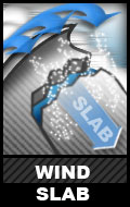
Avalanche Problem 1over the next 24 hours
| type | aspect/elevation | characteristics |
|---|
 |


Above treeline
Near treeline
Below treeline
|
|
|
description
Wind equates to wind slabs. Deposition depth will vary from fragile wind skins to hollow hard slabs 4-6" thick. |

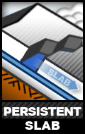
Avalanche Problem 2over the next 24 hours
| type | aspect/elevation | characteristics |
|---|
 |


Above treeline
Near treeline
Below treeline
|
|
|
description
I know this may look like a weird distribution but let me explain. Above tree-line starting zones have been scoured, lower elevation areas sheltered without the slab/weak layer/bed surface recipe. Mid-elevation....still holds the deepest deposits of snow and historically the steepest slope angles and most trigger points in the La Sals. |
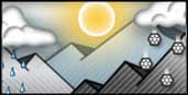 |
weather Wednesday: Sunny, with a high near 25. North northeast wind around 5 mph. |
| general annoucements The Friends of the La Sal Avalanche Center has been an important partner of the UAC-Moab for over 20 years by providing field observers, weather instrumentation, maintaining weather stations and funding. Go to their www.moabavalanche.org to donate today! |