Donate to Our Spring Campaign or Bid on our Spring Auction to Support Forecasting

Forecast for the Skyline Area Mountains

Brett Kobernik
Issued by Brett Kobernik on
Wednesday morning, March 5, 2025
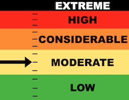
The Manti Skyline has a MODERATE avalanche danger rating today.
The new snow is mostly stable. If you hunt around, you might find a recently formed wind drift that could crack out on you.
While becoming less likely, there is still a chance that a person could trigger an avalanche that breaks deeper into older weak sugary snow.
Low
Moderate
Considerable
High
Extreme
Learn how to read the forecast here
Special Announcements
I am pleased to announce that we have a new version of our Utah Avalanche Center app available. This is a huge improvement over our older version which I disliked and did not recommend to anyone. This version has an inclinometer for measuring slope angles. We plan to add new features on the next version this summer but this is a great start and again, a huge upgrade from our previous version.
ANDROID VERSION HERE
IPHONE VERSION HERE
Weather and Snow
Current Conditions: The new snow greatly improved riding conditions and I found good riding while traveling around on my sled on Tuesday. Temperatures stayed in the mid to upper 20s on Tuesday and dropped to about 20˚F overnight. Wind was slightly breezy in places on Tuesday but overall fairly light from the west.
Mountain Weather: We'll see increasing clouds as the day goes on as another storm moves in. Temperatures will get into the 30s today. Wind looks generally light from the south but may increase in speed as the day goes on. The storm will start tonight and linger through Friday with different periods of snowfall on and off during that time. Models indicate something like 8 to 12 inches of snow by the time it's done.
Ad
Avalanche Problem #1
Persistent Weak Layer
Type
Location
Likelihood
Size
Description
I found the new snow to be mostly stable on Tuesday. There was a little wind so you might find fresh drifts that are sensitive today. Overall, the new snow is fairly well behaved.
The real danger out there is the lingering chance for triggering an avalanche that breaks deeper into older weak sugary faceted snow. The new snow did not add that much weight so those older layers didn't get stressed much. Also, I am seeing strength improvement with those older layers. In locations where the snowpack is deeper, there is no doubt that the older layers have gained some strength. In shallower spots, the pack remains quite loose and sugary. This makes for difficult decision making. If you are getting onto steep slopes, you need to be ABSOLUTELY SURE you are in locations where the snowpack is deep and more stable.
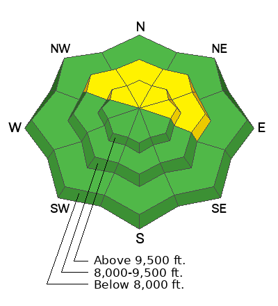
North through east facing slopes where the snowpack remains shallower than 4 feet deep or so are the places where you are most likely to find trouble.
General Announcements
This forecast is from the U.S.D.A. Forest Service, which is solely responsible for its content. This forecast describes general avalanche conditions and local variations always occur.