Donate to Our Spring Campaign or Bid on our Spring Auction to Support Forecasting

Forecast for the Ogden Area Mountains

Drew Hardesty
Issued by Drew Hardesty on
Tuesday morning, January 14, 2020
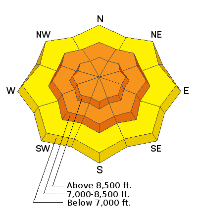
A CONSIDERABLE danger exists at the mid and upper elevations on steep wind drifted slopes. Natural avalanches may be possible today, particularly with natural cornice release. Human triggered avalanches are expected. They'll be most prominent on north to east to south facing slopes but scattered across the compass. Shallow wind drifts exist even at the low elevations.
Sluffing and fresh wind drifts are expected with the midday storm.
Low
Moderate
Considerable
High
Extreme
Learn how to read the forecast here
Special Announcements
Get discount lift tickets HERE. Thanks for this generous support from Utah Ski Resorts and Ski Utah. All proceeds go directly to supporting the UAC.
Weather and Snow
Skies are mostly cloudy with warm and windy conditions overnight. Most areas picked up 4" yesterday.
Temps have steadily risen and are currently in the upper teens to low 20s. The west to southwest winds continue to be the punisher, averaging 30-35mph with gusts to 45. It's also important to note that winds continue to be moderate to strong in the mid-elevations...and even gusty down low.
Today we'll see increasing clouds and snow filling in during the day with 4-8" possible. Winds will remain moderate to strong from the west.
Recent Avalanches
Ski area control teams reported lots of wind transport and frequent mitigation of fresh wind slabs over the course of the day. Cornices were also reported to be sensitive and breaking wide.
Ad
Avalanche Problem #1
Wind Drifted Snow
Type
Location
Likelihood
Size
Description
Wind slabs are scattered across the compass and can be triggered on steep terrain. Some may run naturally today.
NOTE that they will be found on nearly all aspects and even at the lowest elevations. I may have triggered my lowest elevation avalanche yesterday in Provo on a steep wind loaded south facing test slope at 6700'.
NOTE that these wind drifts may be sensitive and triggered from a distance...and/or they may be stubborn and resist failure until the 3rd skier or rider moves over them. They'll also be found well off the ridgelines and mid slope.
CRACKING AND COLLAPSING are key clues to instability.

CORNICES are becoming unruly and will break back farther than expected....and today are likely to trigger wind slabs on steep slopes below.
General Announcements
This information does not apply to developed ski areas or highways where avalanche control is normally done. This forecast is from the U.S.D.A. Forest Service, which is solely responsible for its content. This forecast describes general avalanche conditions and local variations always occur.