Donate to Our Spring Campaign or Bid on our Spring Auction to Support Forecasting

Forecast for the Logan Area Mountains

Toby Weed
Issued by Toby Weed on
Saturday morning, January 23, 2021
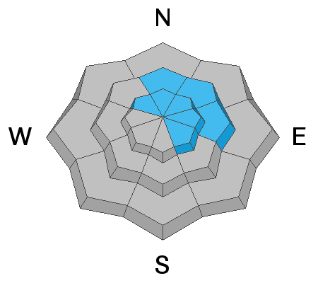
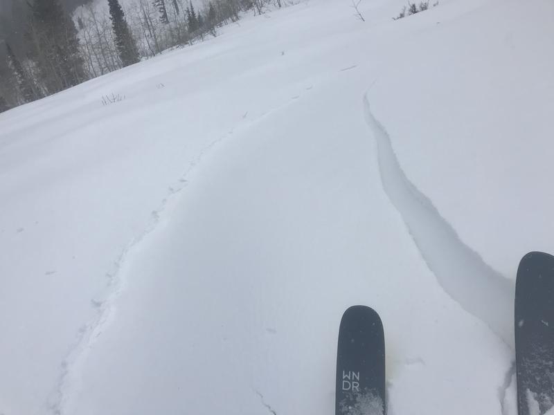
Dangerous avalanche conditions exist and there is CONSIDERABLE danger on upper and mid elevation slopes with significant accumulations of heavy new snow. People are likely to trigger dangerous slab avalanches failing on a sugary buried persistent weak layer near the ground. With more accumulation overnight and more snow likely to fall today, the avalanche danger is probably higher in the Southern Bear River Range, the Logan Peak Area, and the Wellsville Range. Heavy snow and drifting from moderate west wind during today's winter storm will cause rising avalanche danger, natural avalanches are increasingly possible, and HIGH danger could develop on steep upper elevation slopes.
  • AVOID TRAVEL IN AVALANCHE TERRAIN. Stay off and out from under slopes steeper than about 30 degrees.
Low
Moderate
Considerable
High
Extreme
Learn how to read the forecast here
Avalanche Warning
RECENT HEAVY SNOW HAS OVERLOADED A VERY WEAK SNOWPACK AND HAS CREATED WIDESPREAD AREAS OF UNSTABLE SNOW. BOTH HUMAN TRIGGERED AND NATURAL AVALANCHES ARE LIKELY. STAY OFF OF AND OUT FROM UNDER SLOPES STEEPER THAN 30 DEGREES.
Weather and Snow
It looks like 4 or 5 inches of new snow fell overnight in the Central Bear River Range. The existing snowpack is generally quite shallow in the Logan Zone, and we have a serious problem with widespread very weak sugary snow and a dangerous persistent weak layer near the ground on most slopes. You sink all the way to the ground if you hop off your sled when you're off the beaten track, and breaking trail on skis is very difficult in untracked terrain because you sink way too deeply into loose sugary snow.

Expect avalanche danger to contnue to rise on steep slopes where significant snow accumulates, because very weak preexisting snow is widespread and it plagues snow covered slopes at all elevations facing every direction. More snow is likely next week in a much more progressive weather pattern.
Recent Avalanches
No avalanches have been reported in the Logan Zone since the first week of 2021, when conditions were quite active.
  • A local rider was completely buried in Steep Hollow on 1-8-2021. Thankfully, he was rescued in time by his riding partners. Our accident report shows the details.. HERE
  • In early January there were several large remotely triggered avalanches in the Logan Zone, all triggered by sledders or snow bikers, and luckily from a distance. See the avalanche list HERE.
Ad
Avalanche Problem #1
Persistent Weak Layer
Type
Location
Likelihood
Size
Description
Very weak sugary or faceted snow near the ground is widespread across the region, and people could trigger avalanches where a slab of more cohesive snow has formed on top of the weak snow.
  • Avalanches failing on a buried persistent weak layer might be triggered remotely, from a distance, or worse from below!
  • Cracking and collapsing of the snow are a red flag, indicating unstable snow conditions.
Still finding propagation in snow pit tests Thursday on an east-northeast facing slope at 8400' in the backcountry on the backside of Beaver Mountain. This layer could easily be reactivated by the new load from today's storm.
Avalanche Problem #2
Wind Drifted Snow
Type
Location
Likelihood
Size
Description
Moderate westerly winds with this storm are enough to create deep drifts of soft snow and drift significant amounts of new snow into lee slope avalanche starting zones. Soft wind slab avalanches triggered by people are likely today on steep mid and upper elevation slopes.
  • Watch for and avoid drifted snow at upper and mid elevations near ridge tops and in and around terrain features like gullies, scoops, cliff bands, and sub ridges.
We cracked out this shallow but hard wind slab near the saddle on Beaver Mountain Backside Thursday, leading me to beleive there are more old drifts out there that could be triggered.
Avalanche Problem #3
New Snow
Type
Location
Likelihood
Size
Description
Looks like 4 or 5 inches of fairly heavy snow fell in the central and northern Bear River Range overnight, with probably a bit more in the southern part of the Bear River Range, the Logan Peak Area and the Wellsville Range. A band of heavy snowfall could set up over the southern part of the zone today, and significant accumulations are possible. Natural avalanches of new snow are possible if so, especially during periods of particularly heavy snowfall. The load of the new snow may be enough in some areas to overload buried persistent weak layers that are widespread across the zone, and large natural and human triggered avalanches could result.
Additional Information
Do you have the essential avalanche rescue gear (transceiver, probe, and shovel) and do you know how to use them? Watch this video to see how the three pieces of equipment work together. HERE
This video is from the 1-8-2021 avalanche in Steep Hollow that completely buried a local snow bike rider.

Please use the Beacon Training Park and Beacon Checker at the Franklin Basin Trailhead...
General Announcements
Thanks to the generous support of our local resorts, Ski Utah, and Backcountry, discount lift tickets are now available. Support the UAC while you ski at the resorts this season. Tickets are available here.
Visit this website with information about Responsible Winter Recreation by the Utah Office of Outdoor Recreation.
EMAIL ADVISORY. If you would like to get the daily advisory by email you subscribe HERE.
Remember your information can save lives. If you see anything we should know about, please help us out by submitting snow and avalanche observations....HERE. You can also call us at 801-524-5304, email by clicking HERE, or include #utavy in your tweet or Instagram.
I will update this forecast by around 7:30 tomorrow morning.
This forecast is from the USDA Forest Service, which is solely responsible for its content. The forecast describes general avalanche conditions and local variations always occur.