Observer Name
JP
Observation Date
Friday, January 26, 2024
Avalanche Date
Friday, January 26, 2024
Region
Salt Lake » Little Cottonwood Canyon » Superior
Location Name or Route
Superior
Elevation
9,800'
Aspect
Southeast
Trigger
Skier
Trigger: additional info
Unintentionally Triggered
Avalanche Type
Soft Slab
Avalanche Problem
Wind Drifted Snow
Weak Layer
New Snow/Old Snow Interface
Depth
3"
Width
45'
Vertical
100'
Comments
I'm writing this more so as an observation of conditions but I did technically trigger an avalanche so it is marked as so.
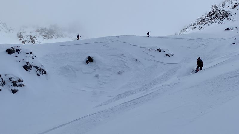
I skied superior with a group of people this morning around sunrise. Our primary concern was potential wind loading from NW winds (typical for the south face). The previous storm underperformed with Alta only recording 4 inches. Despite this relatively smaller amount of snow available for transport wind loading was very obvious on South to East aspects. We got cracks and popped off small wind pockets on the ridge up to superior (eastern facing side) and on the SE face while skiing down. 6-9 inches deep falling on the crust below the new snow and propagating further than anticipated. Very soft slabby in nature. Also a lot of running sluff while skiing.
The avalanche mentioned and shown below was triggered on the skiers left roll over between the middle and lower aprons. The crown was 3 inches deep and stretched for about 45 feet. It didn't run very far and concern level was very low. I'd call it a slightly wind effected soft storm slab.
Mostly submitted this to make a note of the wind loading as it wasn't mentioned in the avy report when I looked. Also sorry for lack of proper abbreviations and potential grammar mistakes, I'm on my lunch break and tryna eat.

Video
Coordinates


